
A wet summer comes to a close
Author: Press Office
13:27 (UTC+1) on Thu 31 Aug 2017
The end of August brings a close to a wet summer and although you might not think it, it has also been warmer than average.
This summer has been most notable across the UK for being wetter than average. Each of the three months have exceeded their long-term average rainfall totals in many areas. Broadly speaking, June was wettest in the north and July was wettest in the south.
The rainfall has not been record breaking with 2007 (357.8mm) , 2009 (323.0mm) and 2012 (379.2mm) being recent years with summers where more rainfall was recorded. The UK received 320mm of rainfall over the summer (1 June – 30 August), 32.8% more than the 241mm average. This makes this summer the UK’s 11th wettest on record, with just one day of the month left to go. Western Scotland has been the wettest region of the UK with 509.6mm up to 30 August. It has been Scotland’s fifth wettest Summer on record, with data for August 31st still to be recorded.
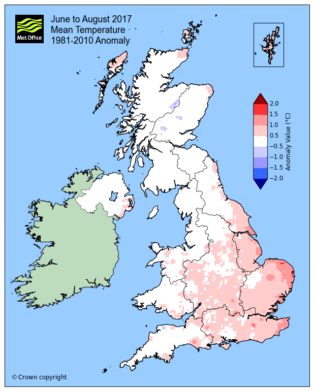
Although it may feel like a distant memory, the fine spells of weather which included the hottest days of the year in late June and early July were enough to ensure the full summer mean temperatures will be slightly warmer than average. June was in fact the fifth warmest in records dating back to 1910.
The UK as a whole has been 0.41°C above the long-term average. East Anglia has been the warmest region compared to the long-term average, being 0.85°C warmer. Northern Scotland has been the coolest region in comparison, just 0.01°C above its average.
Met Office climate scientist Dr Mark McCarthy said: “People may well remember the 2017 summer as a bit of a damp squib, but interestingly although it has been notably wetter than average for many areas it has also be warmer than average. The warm settled periods at the end of June and the beginning of July helped boost the average temperatures.”
|
Provisional Summer 2017 data (1 June – 30 August) |
Mean temp (°C) |
Sunshine (hours) |
Rainfall (mm) |
|||
|
Actual |
Diff from avg |
Actual |
% of avg |
Actual |
% of avg |
|
|
UK |
14.73 |
0.41 |
485.5 |
96.2 |
320.0 |
132.8 |
|
England |
16.06 |
0.61 |
551.8 |
98.8 |
249.8 |
129.0 |
|
Wales |
14.83 |
0.41 |
489 |
93.9 |
370.3 |
129.6 |
|
Scotland |
12.63 |
0.11 |
387.8 |
91.2 |
416.2 |
136.5 |
|
N Ireland |
14.06 |
0.18 |
409.1 |
96.0 |
357.8 |
140.3 |
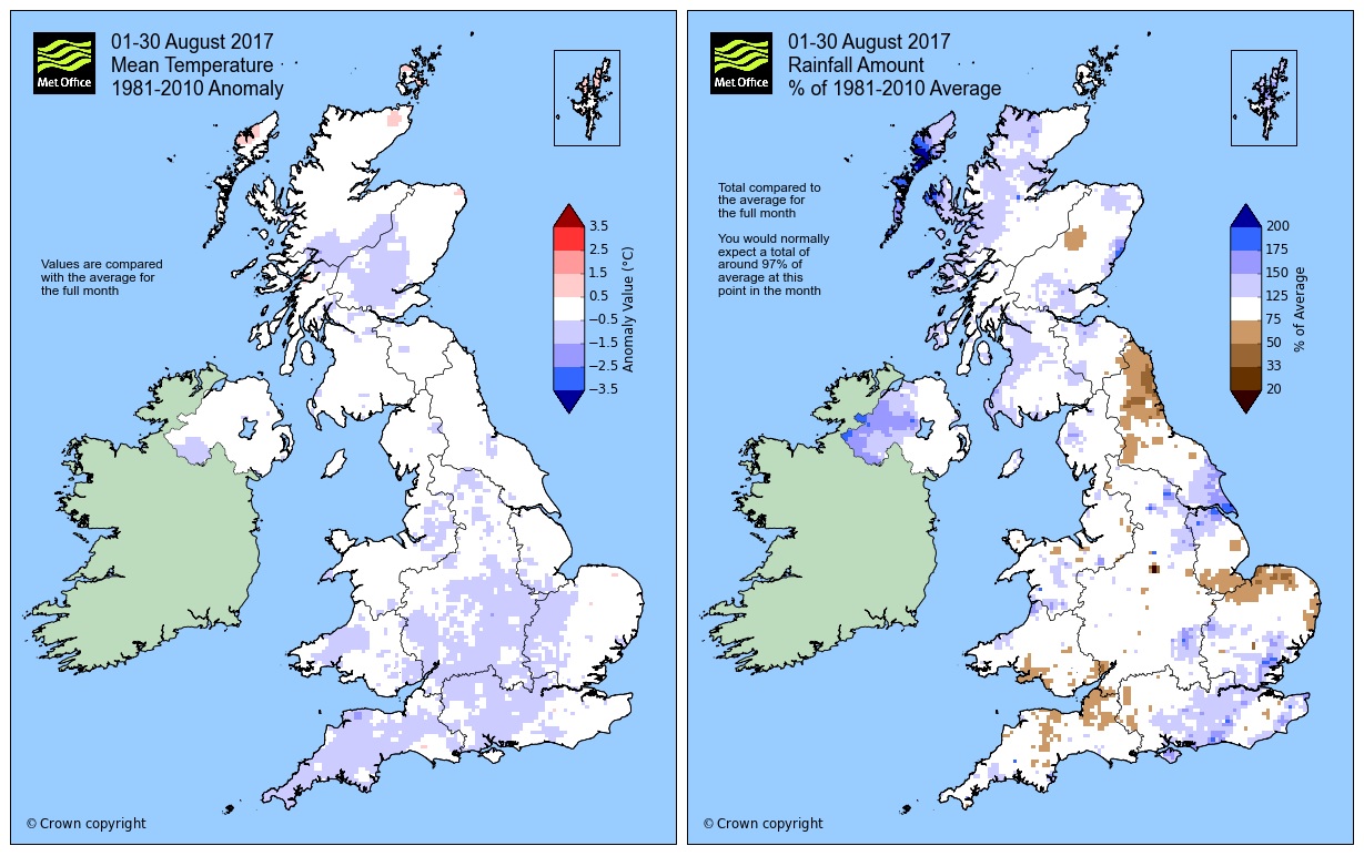
August itself has been a fairly non-descript month in terms of statistics. Figures up to 30 August show the UK has so far been 0.3°C cooler than average with one day left in the month. All regions are slightly cooler than average with only Caithness, Ross and Cromarty, Sutherland, Western Isles, Shetland and Orkney being above their average temperatures.
Rainfall has been just over the average for the UK as a whole, Wales has come in just under with 99% of the average rainfall with one day of statistics still to include. Northern Scotland and Northern Ireland have been the wettest regions so far compared to their averages with 129% of mean rainfall, 155.5mm and 125.8mm respectively.
|
Provisional August (1-30) 2017 data |
Mean temp (°C) |
Sunshine (hours) |
Rainfall (mm) |
|||
|
Actual |
Diff from avg |
Actual |
% of avg |
Actual |
% of avg |
|
|
UK |
14.6 |
-0.3 |
151.8 |
93 |
99.4 |
111 |
|
England |
15.7 |
-0.4 |
172.3 |
94 |
69.3 |
100 |
|
Wales |
14.6 |
-0.4 |
144.4 |
86 |
106.7 |
99 |
|
Scotland |
12.8 |
-0.2 |
125.3 |
93 |
142.7 |
122 |
|
N Ireland |
14 |
-0.3 |
120.4 |
89 |
125.8 |
129 |
The month of September will get off to a fine start for many once Friday’s showers in the east die out, with Saturday sunny for most following a chilly night as a ridge of high pressure moves over the UK. On Sunday a warm front will bring rain in from the west reaching most areas of the UK, but the front will weaken as it moves eastwards leaving little rain for the far east of the country by the night time. Monday will be cloudier but drier with just a little drizzle in places.
You can keep up to date with the weather using our forecast pages, on our popular mobile app which is available for iPhone from the App store and for Android from the Google Play store and by following us on Twitter and Facebook, as well as using.