An unsettled period on the horizon
Author: Press Office
12:20 (UTC+1) on Fri 4 Oct 2024
Turning unsettled again as we move through the weekend, then, ex-Hurricane Kirk likely reaching northwest Europe from midweek and potentially bringing disruptive weather for the UK.
High pressure brings a fairly quiet day on Friday, with sunny spells for many. It will be cloudier in the far west though, with patchy rain, especially over Northern Ireland and western Scotland.
A fine day across much of England and Wales with sunny spells 🌤️
— Met Office (@metoffice) October 4, 2024
Cloudier and breezier in Northern Ireland and western Scotland with patchy outbreaks of rain ☔ pic.twitter.com/IR45n3QA18
Turning more unsettled over the weekend
There’s another fine day for England and much of Wales on Saturday. However, unsettled conditions already affecting Northern Ireland and parts of Scotland will gradually push to all areas as low pressure moves in from the west. Cloud and rain, which could be heavy at times, will affect into Northern Ireland and southwestern parts of England and Wales by Saturday evening, with rain continuing to spread eastwards overnight, easing as it does so.
Sunday sees another band of rain, which could be heavy at times, spreading eastwards, bringing a blustery day with sunny spells and heavy showers. It will be feeling quite mild for the time of year though, with highest temperatures likely to be around 18°C.
As we move into the new working week, Monday and Tuesday bring a mixture of sunshine and showers, the heaviest and most frequent in the west, with conditions drier in the east. Unsettled conditions likely to persist for the remainder of the week with the potential for disruptive rain and wind.
A weekend of two halves 👇
— Met Office (@metoffice) October 4, 2024
• Sunny Saturday for much of England and Wales 🌤️
• Soggier Sunday with cloud, rain and heavy showers ☔ pic.twitter.com/vRwSRI602l
Possible aurora sightings for some
There’s a potential for some aurora visibility for some, primarily in the north of the UK, over the next few nights.
Met Office Space Weather Manager Krista Hammond said: “There is the potential for a coronal mass ejection to arrive at Earth late on Friday or early on Saturday, which could lead to visible aurora for Scotland, Northern Ireland and parts of northern England.
“In addition, we recently observed an X9 solar flare – the largest of this solar cycle so far. The accompanying coronal mass ejection is likely to arrive at Earth overnight on Saturday into Sunday, meaning that enhanced auroral visibility is possible further south across central England and similar latitudes, though cloud and rain could hamper viewing potential for some.”
Find the latest space weather forecast from the Met Office.
Potentially disruptive weather possible later next week
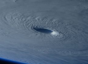
From midweek, Hurricane Kirk, which is currently in the Atlantic, poses a threat of bringing disruptive rain and wind for some, though it will have lost its status as a hurricane by the time it reaches northwest Europe.
Chris Bulmer is a Deputy Chief Meteorologist at the Met Office and said: “Kirk over the North Atlantic will lose its status as a hurricane early next week before being swept towards northwest Europe. The resulting low pressure system will still have the potential to bring disruptive rain and winds to some areas, including parts of the UK, from the middle of next week.
“There remains much detail to work out on the exact track and timing of the system. Across the UK, parts of England and Wales look to have the greatest risk of heavy rain and strong winds during Wednesday and Thursday. However, a more southward track of this system, which is equally plausible at this stage, would see the most disruptive conditions impact France. The need for warnings will be kept under review over the coming days, so it’s important to stay up to date with the latest forecast.”

What is a hurricane?
Hurricanes are tropical features and require sea temperatures much higher than those around the UK, even in the summer. Hence, hurricanes cannot form at our latitudes.
However, we are sometimes affected by deep depressions that were originally hurricanes which have moved to higher latitudes. Such depressions are classified as 'ex-hurricanes' or 'ex-tropical cyclones' since they have changed their prime energy source from the warm ocean surface to the clash of warm tropical and cold polar air.
By the time Kirk potentially reaches waters near the UK, it will have lost its power and be known as ‘ex-hurricane Kirk’.
If the weather system reaches the criteria for naming it a storm due to its possible impacts, it would be known as Storm Kirk.
Find out more about hurricanes
Find out more about storm naming
Stay up to date
You can find the latest forecast on our website, on YouTube, by following us on Twitter and Facebook, as well as on our mobile app which is available for iPhone from the App store and for Android from the Google Play store.


