Numerous rain warnings issued
Author: Press Office
13:18 (UTC) on Wed 6 Dec 2023
Further heavy rain is forecast to fall on already saturated ground with rain and flood warnings issued.
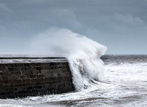
Areas of low pressure will bring very wet and windy conditions to the UK, displacing the cold weather that has bought frequent frosts, snow and ice to some regions. The highest rain totals will be focused in western parts of the UK over the next few days, falling on already very wet ground.
Met Office Chief Forecaster, Neil Armstrong, said: “After a relatively calm day on Wednesday, wet and windy weather will move in from the west on Wednesday night. Low pressure will drive several days of unsettled conditions with heavy rainfall the main concern.
“We have issued a number of severe weather warnings for rain across the UK, as much as 80mm of rain could fall in some areas of the west, particularly higher ground. Higher ground in eastern Scotland could even see up to 100mm of rain. Our warnings are likely to be updated so keep up to date with the Met Office forecast.
“The rain will be falling on already very wet ground and where there is still lying snow in the northwest of England and parts of Scotland, snow melt will exacerbate the risk of flooding. It is important to check for flood warnings in your area issued by your local environment agency.”
⚠️ Yellow rain warnings for Thursday across the UK have been updated this morning
— Met Office (@metoffice) December 6, 2023
Latest info 👉 https://t.co/QwDLMfRBfs
Stay #WeatherAware⚠️ pic.twitter.com/kcy66GdahS
A second low pressure will reinforce the heavy rain through Thursday and bring further weather fronts across the UK during Friday and Saturday morning.
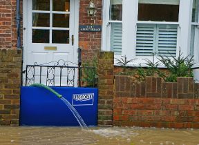
Flood warnings
Flood warnings for the UK are issued by the local environment agencies; Natural Resources Wales, the Scottish Environment Protection Agency, the Department for Infrastructure Northern Ireland and the Environment Agency in England.
A number of flood warnings and flood alerts have been issued across the UK, it is important to stay up to date with warnings in your local area.
Kate Marks, flood duty manager at the Environment Agency, said: “Significant river and surface water flooding impacts are possible in parts of the South West of England on Thursday and Friday, with minor impacts also probable elsewhere in the country.
“We advise people to stay away from swollen rivers and urge people not to drive through flood water as just 30cm of flowing water is enough to move your car.
“People should check their flood risk, sign up for free flood warnings and keep up to date with the latest situation at https://www.gov.uk/check-if-youre-at-risk-of-flooding and follow @EnvAgency on X, formerly known as Twitter, for the latest flood updates.”
Further ahead
As the area of low pressure moves away to the east, there will be a brief calmer spell in the southern half of the UK as a ridge of higher pressure moves in through Saturday afternoon. Showery rain will continue in the northern half of the country.
Although there is still some uncertainty at this stage, another area of low pressure could move close to Northern Ireland on Sunday bringing very strong winds and further spells of rain. This is being monitored by our forecasting team and updates will follow as the forecast evolves with higher certainty.
You can keep up to date with the latest forecast on our website, by following us on Twitter and Facebook, as well as on our mobile app which is available for iPhone from the App store and for Android from the Google Play store.