Extreme weather
Find out in more detail about different types of extreme weather.
Flooding
Flooding can be caused by:
- a large amount of rain - either from really heavy rain or rain over a long period of time
- rapid melting snow
- a combination of high tides and high river levels
- a storm surge
When you have heavy rain for a short period of time that causes flooding, we call this 'flash flooding', because it can happen in a flash! This short-lived but heavy rain only usually causes flash flooding when there are other factors, for example, when drains in the road are blocked so that the water can't drain away, or at the bottom of steep hills as there is nothing to catch the water as it runs down the hill. Often when we have rain for a long period of time we see flooding in some places, usually along river banks and flood plains where there is already a lot of water on the ground, as well as places where we see flash flooding.
In the UK most people don't get affected by flooding from snow melting very often, but in mountainous areas around the world it can be very common, particularly in spring when it can starts to get warmer quite quickly and the snow rapidly turns to water, which will start running downhill, so this can be a big problem for towns and villages in mountain ranges. However, snow melting can cause flooding in the UK, particualrly when we have big snow events, like in 2010/11 and 2018.
If heavy rain happens when the tides are high or the rivers are already full of water, flooding becomes more likely . Spring tides are very high tides and come much further inland than usual high tides and cause flooding. Sometimes, though, even when there is a lot of rain over a long period of time, we don't see any flooding along rivers, this is usually when the rivers were running low because there hadn't been any rain for a long time.
Storm surges
Storm surges are like big walls of water being pushed in from the sea in a 'surge' and caused by strong winds and low air pressure from a 'storm'. When air pressure decreases by one hectopascal, sea level rises by one centimetre. A deep depression, with a central pressure of about 960 hPa, causes the sea level to rise half a metre above the level it would have been had pressure been about average (1013 hPa). The opposite happens when pressure is above average, the sea level will fall.
Storm surges create large waves. The highest waves wash away protective dunes, batter sea walls and break over coastal defences causing flooding.
The greatest storm surge on record for the North Sea as a whole occurred on 31 January and 1 February 1953.
Thunderstorms
Most thunderstorms are associated with towering clouds known as cumulonimbus. The right conditions for the formation of a thunderstorm are unstable air and a mechanism for causing air to rise - usually hot, humid air with lots of energy.
While air is rising it is said to be unstable. This instability is the result of a rapid fall of temperature with height, as well as a lot of moisture in the air. This process may be caused by a warm surface; the air near the surface being forced to rise over higher ground or instability within a weather front.
For example, on a summer's day, the land is warmed by the sun, and as the air just above becomes warmer it starts to rise. As it rises it cools, and, if cooled enough, cumulus clouds form at the condensation level - where water vapour turns into a solid. These small, white puffy clouds grow larger and larger as the temperature of the ground increases, causing more warm air to rise. After a time, the top of the cloud turns to ice (usually below a temperature of -20 °C) and streams away in the winds at the level of the cloud top, giving it a characteristic anvil shape.
Lightning
Lightning is a large electrical spark that occurs when there is a difference in charges between a cloud and the ground, or between clouds. It is caused by electrons moving from one place to another. Electrons cannot be seen, but when they are moving extremely fast, the air around them glows, causing the lightning flash. The actual streak of lightning is the path the electrons follow when they move.
An atom consists of three basic parts, a proton (which has a positive charge), a neutron (which has no charge) and an electron (which has a negative charge). Electrons cling to the positively charged centre of the atom because they have a negative electrical charge. During a thunderstorm, some of the atoms in the cloud lose electrons while others gain them.
When a cloud is composed entirely of water droplets, there is very little transfer of electrons. As a storm cloud grows in height, the water droplets higher up become cooler. They continue in the liquid state below 0 °C as supercooled water, but eventually they begin to turn to ice, usually at a temperature below -20 °C. These ice particles often collide. When they do, smaller particles lose an electron to the larger, this means that the smaller particles gain a positive charge and the larger gain a negative charge.
The small particles are propelled towards the top of the cloud by strong internal winds, while the larger particles start to fall. This causes the top of the cloud to develop a strong positive charge.
The larger, negatively charged, ice particles begin to 'capture' supercooled water droplets, turning them instantly to ice and growing, some reaching a sufficient size to start falling.
This leads to the base of the cloud becoming negatively charged which, in turn, induces a positive charge on the ground below. In time, difference in charges between the cloud and ground, or between nearby clouds, becomes large enough to overcome the resistance of the air and there is a massive, very rapid transfer of electrons, which appears as a lightning flash.
Thunder
The word thunder is derived from 'Thor', the Norse god of thunder. He was supposed to be a red-bearded man of tremendous strength; his greatest attribute being the ability to forge thunderbolts. The word Thursday is also comes from his name - Thor's day.
Thunder is the sharp or rumbling sound that accompanies lightning. It is caused by the intense heating and expansion of the air along the path of the lightning. The rumble of thunder is caused by the noise passing through layers of the atmosphere at different temperatures. Thunder lasts longer than lightning because of the time it takes for the sound to travel from different parts of the flash.
You can roughly estimate how far away a thunderstorm is by measuring the interval between the lightning flash and the start of the thunder. If you count the time in seconds and then divide by three, you will have the approximate distance in kilometres. Thunder is rarely heard at a distance of more than 20 km.
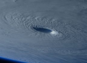
Tropical cyclones
A tropical cyclone is a low pressure system that develops near the equator over tropical or sub-tropical waters, with convection (i.e. thunderstorm activity) and strong winds at low levels, circulating either anti-clockwise (in the northern hemisphere) or clockwise (in the southern hemisphere). Tropical cyclones are also known as hurricanes and typhoons, depending on which country or countries are affected by them.
Tropical cyclones can be seen from satellites and are very distinctive because of their 'eye' - the clear hole in the middle of the cloud, here winds are calm and skies are clear, but at the edge of the eye, at the 'eye wall', the winds are strongest and the rain is heaviest.
Other than strong winds and heavy rains, tropical cyclones also cause damage from hail, lightning, storm surges, flooding and tornadoes.
Tornadoes
Tornadoes are swirling columns of air, spinning rapidly with winds of over 40mph or 60kph - the fastest wind speeds ever recorded for a tornado are over 300mph or 480kph and are the fastest winds ever recorded on Earth.
Tornadoes usually form from big thunderstorms called 'supercells', but can form from other types of storms too, like tropical cyclones. When a thunderstorm is being fed lots of warm, moist air it continues to grow and can begin to rotate. If this rotation begins to lower from the cloud a tornado is beginning to form, but at this stage we call it a funnel cloud. When the funnel reaches the ground it becomes a tornado.
Tornadoes have lots of other names, like whirlwind, twister, or landspout, and are called waterspouts when they occur over lakes or the sea.
There are also phenomenon called dust devils or willy willys, that look like tornadoes, but are very different. These are formed from the ground and don't lower down from cloud like tornadoes do, in fact they mostly form under clear blue skies. Dust devils occur when the ground gets very hot, usually in deserts where the surfaces are sandy or dusty and dry, causing updraughts to form which lift the dust and sand into the air. Unlike tornadoes, dust devils are very short lived and their winds are quite weak and are unlikely to do any damage.
Drought
Drought occurs when there is a lack of rainfall over a long period of time, resulting in water shortages for groups of people, activities or the environment. Droughts have a significant impact on farming and can harm the economy.
Causes of lack of rain
- Water vapour needs to rise high through the atmosphere in order to condense and bring about rain. However, in areas of high pressure, water vapour does not rise and so no rain or clouds will form. When the high pressure stays in an area for a prolonged length of time the result is drought.
- Mountains affect the movement of air too. Air carrying water vapour will rise higher in order to pass over to the windward side of a mountain. As the air rises it cools causing water vapour to condense bringing about rain and when reaching the other side of the mountain it has lost most of its water vapour. The leeward side (the sheltered side) of a mountain is warmer and drier and in some cases a desert so can go through long periods without any rain causing drought.
Droughts can have their effects minimised by using techniques like irrigation or daming rivers to make man made lakes. Ancient Egypt used irrigation by channeling water from the Nile to grow crops, this helped plants to keep growing even when there was little to no rain for months at a time - this technique is still used in parts of the world today.
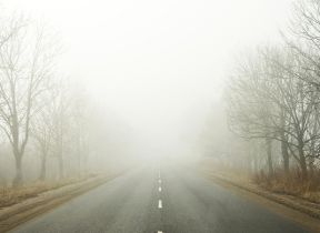
Dust and Sand Storms
Dust and sand storms occur mostly in deserts, or arid and semi-arid areas, when strong winds pick up sand and dust and carry them over large distances. These strong winds can be caused by distant thunderstorms or when there is a large change in pressure across a small area causing fast winds to form.
Dust and sand storms can be very dangerous; they are similar to fog in that they make it very difficult to see so can lead to car crashes. Breathing in dust can be very bad for you and can cause breathing problems, as well as irritating your eyes and skin.
There are lots of other names for dust and sand storms and are associated with the areas they form in, including haboob, harmattan, simoom, sirocco among others.
Blizzards
When you combine strong winds and snow, you get a blizzard. The winds have to be at least 30mph or 48kph and the snow and winds combined have to drop the visibility below 200m for a snow storm to be a proper blizzard.
Blizzards are not very common in the UK, as usually when the winds are strong it tends to make the weather too mild for snow. However, they do occur every year in winter across more northern parts of the UK and through our mountain ranges, occasionally making it into southern parts of the UK, like in the winters of 2010/11 and 2018.