
Wintry weather on the way
Author: Press Office
12:52 (UTC) on Wed 11 Jan 2017
A cold and windy Polar Maritime airmass, with its origins over northern Canada, will spread southwards across the UK in the next 24 hours, bringing a real taste of winter to the whole of the UK from tomorrow (Thursday).
It will be a windy spell of weather and many parts of the UK can expect to see some snow showers and widespread overnight frosts.
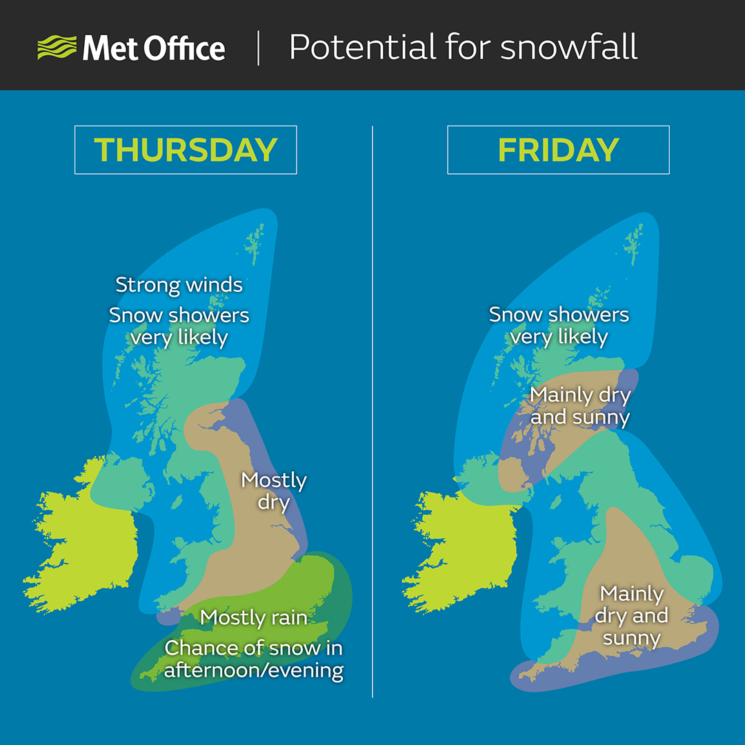
National Severe Weather Warnings have been issued for wind and snow, with the heaviest and most frequent snow showers likely across northern and western Scotland, Northern Ireland and around Irish Sea coasts, but eastern coasts will also be affected at times on Friday and Saturday. There will be gales which could lead to temporary blizzard conditions as well as a risk of hail and thunder in some locations.
Although the south of the UK is likely to avoid the majority of the snow showers, this area will have a wet day on Thursday with persistent heavy rain for much of the day, which is expected to turn to sleet or snow for a time in the afternoon and evening.
Paul Gundersen, Chief Meteorologist said: “Most northern areas are very likely to see snow showers at times over the next few days, but the situation over the southern half of England is more complicated.
“Southern counties of England and Wales can expect a cold and wet day with some heavy rain on Thursday, but there’s an increasing chance this will turn to sleet or snow, especially over hills, during the afternoon and evening.
“There is a chance of snow settling bringing disruption to transport during the evening rush hour and possibly interruptions to power supplies, this more likely across East Anglia and southeast England. As skies clear on Thursday night it is likely to become icy in many areas.
“Forecasting snow is always challenging and there’s often a fine line between whether it will rain or snow in a particular location depending on slight changes in air temperature. Keep an eye on the forecast and warnings for your area for the latest information.”
Daytime temperatures are likely to be around 2 to 5 °C, but the strong to gale force winds will make it feel much colder. Overnight, a frost and ice will develop in most places with some severe frost likely where there is snow on the ground in the north. Temperatures could dip below -10 °C over snow cover in rural areas.
For Friday and as we head into the weekend it looks like the cold weather will continue although snow showers will become more isolated. Inland areas will be more sheltered and so may escape any snow altogether.
Prof Paul Cosford, Director for Health Protection & Medical Director at Public Health England, said: "The Met Office is forecasting a spell of colder weather from this afternoon, with likely snow and icy conditions. Think now about what you need to do to prepare: if you need vital medicine or food get it before the bad weather arrives. People with underlying health conditions, very young children and those aged over 65 are at greatest risk, so think what you can do to help others.
“Keeping your home heated to at least 18C, wearing lots of thin layers instead of fewer thicker ones, and if you have to head out using footwear with a good grip are all ways to deal with this weather and stay well this winter."
There are many ways you can ensure you and your family stay well this winter and, if you are travelling, to plan your journey and prepare your vehicle. There are many more hints, tips and advice on our Get Ready for Winter website.
Keep up to date with the weather using our forecast pages and by following us on Twitter and Facebook, as well as using our new mobile app which is available for iPhone from the App store and for Android from the Google Play store. Search for "Met Office" in store.