Amber rain warnings issued in Scotland
Author: Press Office
10:18 (UTC+1) on Fri 6 Oct 2023
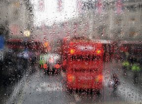
Amber warnings have been issued by the Met Office as the heavy and slow-moving rain impacting much of Scotland move north-eastwards through to Sunday morning.
While those in the southern half of the UK are experiencing a period of warm settled weather, a weather front over Scotland is bringing heavy and persistent rain. This rain is associted with impactful conditions, flooding and severely disrupted travel.
Met Office Chief Meteorologist Neil Armstrong said: “Prolonged heavy rain is causing widespread disruption for much of Scotland. While Saturday into Sunday will be widely very wet for Scotland, the heaviest and most disruptive rain has been affecting western and central Scotland so far, but as our recent warnings indicate this heavy rain will also affect areas to the north and east.
“Within the Amber warning areas 60-80mm of rain is likely, with 180mm or more in total for some of the wettest spots across Argyll. Rain is expected to slowly clear to the north during Sunday. We’ll continue to review warnings so it’s important for everyone to stay up to date with the latest forecast for their area.”
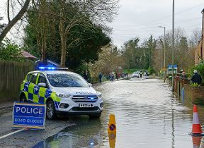
Ruth Ellis, Flood Duty Manager for the Scottish Environment Protection Agency (SEPA), said: “This is a major rainfall event as we are expecting to see significant prolonged heavy rain throughout Saturday across the Southern Highlands and western Central Belt, with further heavy rain in the north on Sunday.
“We’re likely to see extensive river and surface water flooding impacts, including property flooding and widespread transport disruption. We would strongly advise people to sign up to Floodline to receive free updates for where they live, or travel through, directly to their phone. People can also check our Flood Updates for all the latest information and the three-day Scottish Flood Forecast to see what conditions are expected further ahead.
“We will be keeping a very close eye on the situation and monitoring 24/7 along with the Met Office and other partner agencies”.
Stein Connelly from Transport Scotland said: “It’s likely the heavy rain forecast this weekend will bring disruption to the transport network in Scotland, so it’s important people plan their journeys before they set off.
“Motorists should make sure their routes are available, follow the travel advice from Police Scotland and drive to the conditions. The Traffic Scotland Twitter/X page is regularly updated and the mobile website - my.trafficscotland.org - lets people get the latest information on the move.
“If you are planning to travel by train, ferry or plane, please check with your operators to see if the conditions are having any impact on your services.”
It's quick and easy to check if your property is at risk of flooding. Just put your postcode in this flood risk checker to find out your risk. There is also a flood risk service for England.
A wider yellow warning for rain is also in force which covers a wider area of Scotland, and heavy rain is also expected for parts of northern England today and tonight.
A spokesperson from British Geological Survey said: "The period of heavy rain, forecast for northern, western, central, eastern and parts of southern Scotland, could lead to an increased potential for debris flows and shallow landslides on natural and man-made slopes."
Rainfall and climate change
In the UK’s recent climate, although observations show large variability in annual, seasonal, and decadal rainfall, large rainfall totals exceeding 50mm per day have become more common during the final three months of the year.
As the atmosphere warms due to human induced climate change it can hold more moisture, at a rate of around 7% more moisture for every degree of warming. On a simple level, this explains why in many regions of the world projections show an increase in precipitation as a consequence of human induced climate change.
In the future, climate projections for the UK indicate that in October, November and December, areas of the UK will likely see more days with rainfall totals over 50mm, but particularly in the west.
Settled and warm further south
While heavy rain dominates the weekend forecast in the north, those further south will see some unseasonable warmth developing, likely peaking around 25°C in southern and central England on Sunday or Monday.
Met Office Deputy Chief Meteorologist Chris Almond said: “There’s a big contrast in conditions across the UK through the weekend. While frontal rain dominates in the north, warmer air and high pressure is developing further south, which will bring some unseasonable warmth for much of southern and central England and Wales.
“Warmth to the south is likely to continue at least at the start of next week, before a likely gradual return to a more typically autumnal weather regime.”
You can check the latest forecast on our website, by following us on Twitter and Facebook, as well as on our mobile app which is available for iPhone from the App store and for Android from the Google Play store.
Updated at 16:38 (UTC+1) on Sat 7 Oct 2023