Second Red warning issued
Author: Press Office
12:32 (UTC+1) on Fri 20 Oct 2023
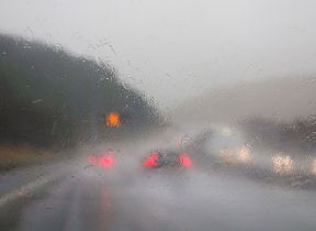
Storm Babet brought significant impacts, particularly to eastern Scotland and the exceptionally wet and unsettled weather will continue through today.
A second red warning is in place today for parts of eastern Scotland where we could see a further 70-100 mm of rain, with the highest accumulations over the hills.
⚠️⚠️🔴 Red weather warning issued🔴⚠️⚠️
— Met Office (@metoffice) October 20, 2023
Exceptionally heavy and persistent rain across eastern Scotland
Saturday 0000 – 2359
Latest info 👉 https://t.co/QwDLMfRBfs
Stay #WeatherAware ⚠️ pic.twitter.com/30IaJ7E00H
Met Office Chief Meteorologist, Andy Page, said: “This is not usual autumn weather. This is an exceptional event, and we are likely to continue to see significant impacts with the potential for further flooding and damage to properties. There are numerous National Severe Weather Warnings in place for both rain and wind .”
“Today the heavy rain is becoming confined to east and north east Scotland with a number of warnings still in place across parts of Scotland, including a second red warning covering parts of Angus and Aberdeenshire with 70-100 mm rain possible during the warning period. This has the potential to cause further impacts in this already hard-hit area.”
Elsewhere, there is the potential for heavy rain and showers in the South East of Englanf today.
Warnings will continue to be updated over the coming days, so it is important to stay up to date with the Met Office forecast and warnings in your area.
Be prepared for potential flooding
Pascal Lardet, SEPA Flood Duty Manager, said:
“There is exceptional rainfall forecast for parts of Scotland and this will lead to significant flooding from both surface water and rivers.
“Regional Flood Alerts were issued over the last two days to provide early awareness, and localised Flood Warnings started to be issued this morning. More will be issued across the day, so I do encourage people to check our Flood Updates for all the latest information. You can also follow @SEPAFlood on X. However, it is important to stress that not all areas that could be affected have Flood Warning schemes, so please do take a Flood Alert in your area as advance notice that you could be affected.
“Follow the advice of the emergency services and take action now to protect yourself and your property. Hazards can be hidden, so please don’t walk or drive into flood water. Remember that not only is flood water likely to be dirty, 30 cm of fast flowing water can move an average family sized car, and just 15 cm of fast flowing water could be enough to knock you off your feet.”
Katharine Smith, flood duty manager at the Environment Agency, said:
“Persistent and heavy rain brought by a combination of Storm Babet and following weather systems means significant river flooding is possible, and localised surface water flooding probable across many parts of the north of England and East Midlands today and into Saturday. Further flooding is expected from Saturday into Sunday in parts of the Midlands.
“Environment Agency teams are out on the ground and have operated flood barriers and storage areas. Temporary defences, including pumps and barriers, are lined up ready to minimise the impact of flooding where needed. Flood gates have also been closed in affected areas. We also advise people to stay away from swollen rivers and urge people not to drive through flood water as just 30cm of flowing water is enough to move your car.
“People should check their flood risk, sign up for free flood warnings and keep up to date with the latest situation at https://www.gov.uk/check-if-youre-at-risk-of-flooding and follow @EnvAgency on X, formerly known as Twitter, for the latest flood updates.”
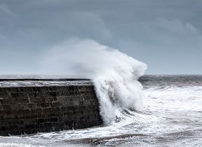
Stay safe near the coast
RNLI Water Safety Partner, Sam Hughes, said: “The forecasted strong winds along with heavy rain are likely to cause dangerous conditions for those visiting the coast around the UK and Ireland.
“The RNLI advises staying a safe distance away from the water and cliff edges as the conditions could knock you off your feet or wash you into the sea. It is not worth risking your life.
“If you see someone else in danger in the water, call 999 or 112 and ask for the Coastguard if by the coast, or the fire service if inland. If you have something that floats that they can hold on to, throw it to them. Don’t go in the water yourself – you may end up in difficulty too.”
The RNLI advice is:
- Stay well back from stormy, wintery seas and cliff edges
- Check the weather forecast and tide times before you go out
- Take a phone with you
- In an emergency call 999 or 112 and ask for the Coastguard
Further ahead
Met Office Expert Meteorologist Chris Almond said: “Sunday looks like a quieter day for many, although there will still be some showers around. However, in lighter winds and with temperatures around average, it could feel comparatively pleasant for a short time. However, on Monday, more heavy rain and showers look like spreading in from the west and southwest, and that sets the scene for the coming week, with all areas seeing further spells of rain at times, albeit with brief drier interludes."
You can keep up to date with the latest forecast on our website, by following us on Twitter and Facebook, as well as on our mobile app which is available for iPhone from the App store and for Android from the Google Play store.
Updated at 10:25 (UTC+1) on Sat 21 Oct 2023