Storm Ciarán
Author: Press Office
15:23 (UTC) on Wed 1 Nov 2023
Storm Ciarán will cross the southern half of the UK during this evening and Thursday. Amber and yellow National Severe Weather Warnings are in place.
Met Office Deputy Chief Meteorologist, Brent Walker, said “Wind and rain warnings associated with Storm Ciarán are in force from tonight through until Friday, with further updates possible. These include Amber warnings for wind for parts of southwest England on Thursday morning and the far south and southeast of England Thursday daytime and early evening.
“Very strong winds are expected along southern coastal areas of England in particular, where gusts of 70 to 80mph are possible, perhaps exceeding 85 mph in a few exposed locations. Further inland, gusts could reach up to 50 or 60mph.
“As well as strong winds, there will be heavy rain across many parts of the UK. Much of southern and western England, Wales, northeast England and eastern Scotland look to see the wettest conditions between Wednesday evening and Friday morning. 20-30 mm of rain is likely to fall quite widely, with 40-60 mm possible over higher ground. Some parts of Wales and southwest England may see 80 mm of rain. This rain will fall on already saturated ground, bringing the risk of flooding.”
Further updates and additions to warnings are possible, so it is important to stay up to date with the Met Office forecast and warnings in your area.
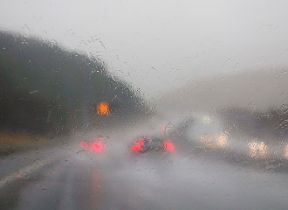
Amy Shaw, National Network Manager at National Highways, said: “It is important to plan ahead for your journey during Storm Ciaran, and if weather conditions become challenging, adjust your driving behaviour and take extra care. National Highways reminds motorists to keep TRIP in mind ahead of journeys at this time of year – Top-up: oil, water, screen wash; Rest: rest every two hours; Inspect: Inspect tyres and lights and Prepare: check your route and the weather forecast.”
With strong winds and heavy rain in the forecast, here is some good advice about driving in severe weather from our partners @TheRAC_UK and @NationalHways#WeatherReadyhttps://t.co/gQ5IWzmCD7 pic.twitter.com/Rpn54KBy5E
— Met Office (@metoffice) November 1, 2023
Flooding possible
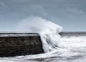
Ben Lukey, flood duty manager at the Environment Agency, said: “Large waves and onshore gales brought by Storm Ciarán could see significant flooding along parts of the south coast tomorrow, while minor impacts are possible along the coast from Dorset to Sussex this evening and along parts of the Yorkshire and Northeast coasts on Thursday.
“Rain from the storm could also see significant surface water and river flooding across parts of the West, South and Northeast of England from later today until Friday, with minor impacts possible more widely on Saturday due to further showers.
“Environment Agency teams are out on the ground clearing any blocking debris from screens and watercourses, operating flood defence assets where required, working with partners and present in those communities that have experienced flooding, looking to minimise the impact on residents.
“We urge people to stay safe on the coast and to remember to take extreme care on coastal paths and promenades. Flooding of low-lying coastal roads is also possible, and people must avoid driving through flood water, as just 30cm of flowing water is enough to move your car.
“People should check their flood risk, sign up for free flood warnings and keep up to date with the latest situation at https://www.gov.uk/check-if-youre-at-risk-of-flooding and follow @EnvAgency on X, formerly known as Twitter, for the latest flood updates.”
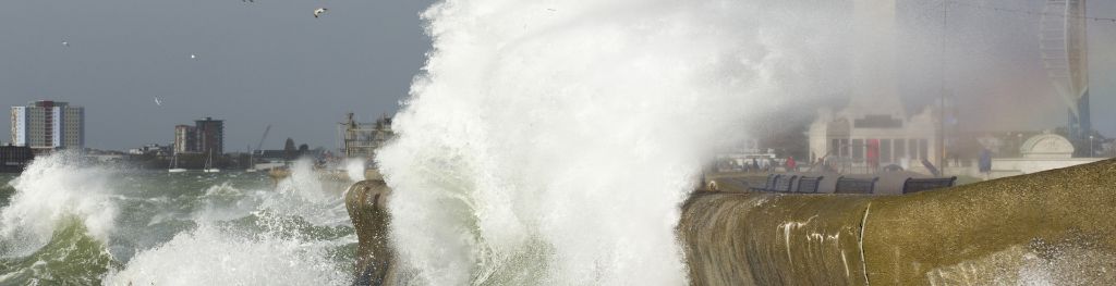
RNLI Water Safety Manager, Ross Macleod said: ‘This rough weather could make visiting our coasts around southern England and Wales treacherous and bring very dangerous sea conditions.
‘Sadly, around 150 people accidentally lose their lives in UK and Irish waters each year and over half of these people didn’t plan on ever entering the water. Slips, trips and falls can be a major factor in these kinds of incidents.
‘While people may want to experience extreme weather around the coast, we would strongly advise against doing so. It is not worth risking your life, so we urge people to respect the water and watch from a safe distance.
‘If you see someone else in danger in the water, call 999 or 112 and ask for the Coastguard. If you have something that floats that they can hold on to, throw it to them. Don’t go in the water yourself – too many people drown trying to save others.’
Met Office Deputy Chief Meteorologist, Brent Walker, said “Once Storm Ciarán has passed, the weather over the weekend continues to look unsettled for many with more showers and rain at times. Warnings will continue to be updated over the coming days, so it is important to stay up to date with the Met Office forecast in your area.”
Storm Ciarán comes on the back of what was provisionally the joint-sixth wettest October on record for the UK, according to the latest Met Office statistics. Find out more here.
Climate Change
Storm Ciarán is a fairly normal Autumn storm for the UK, and due to the natural year-to-year variability in strong winds and windstorm numbers, significant trends have not been detected in observations over the recent climate.
However, there is evidence in climate projections to suggest that the frequency and intensity of windstorms in the UK winter could slightly increase, although, the scale of this change varies between different models.
You can keep up to date with the latest forecast on our website, by following us on Twitter and Facebook, as well as on our mobile app which is available for iPhone from the App store and for Android from the Google Play store.