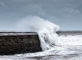
Wet and very windy ahead of Christmas
Author: Press Office
11:51 (UTC) on Tue 19 Dec 2023
The UK will see some potentially disruptive weather later this week, with strong winds in the forecast, as well as periods of rain.
Low pressure dominates the outlook. Through Wednesday, brisk westerlies will bring rain for many, with those in the north and west likely to see the highest rainfall accumulations through the day, though those in the south could also see periods of rain.
A notably deep area of low pressure will track to the north of the UK over the Norwegian Sea through Wednesday night and into Thursday.
This will bring very strong winds and heavy showers to a large portion of the UK, with a Yellow National Severe Weather Warning covering Scotland, Northern Ireland, Northern England and the north of Wales.
Strong winds of up to 80mph will impact northern parts of the UK on Thursday.
— Met Office (@metoffice) December 18, 2023
Find out more ⤵️ pic.twitter.com/2984KWNqXF
Met Office Deputy Chief Meteorologist Chris Almond said: “From late Wednesday into Thursday, strong winds are likely to develop across a large area of the UK. We’ve issued a large yellow warning area where there’s a potential for some impacts, but gusts of 50-60mph are possible for large parts of central and northern areas of the UK.
“Exposed coasts and high ground could see gusts of 70-80mph at times. There’s a chance this low pressure will continue to exert its influence into Friday, so it’s important to stay up to date with the latest Met Office forecast.”
It’ll remain windy for many on Friday, with further periods of rain likely to sweep in from the west, but any snow will be confined to the hills of Scotland.
Christmas weather forecast
It’s a largely showery outlook for the weekend before Christmas, though those further south and east will see fewer showers in general.
Rain will be heaviest in the west and northwest through the weekend, with any wintry showers most likely confined to high ground in northern Scotland.
There are still some uncertainties in the details of the forecast for Christmas Day, as Chris explained: “On Christmas Day there’s a chance of showers almost anywhere, and across the high ground of Scotland in particular, these could fall as sleet and snow, which would technically make it a White Christmas, as we only need to see a single flake falling. However, for the majority of the UK it’s unlikely that we’ll see significant snow, but it will likely feel cold in a strong breeze.
“Beyond Christmas Day a westerly influence on the weather remains the most likely scenario, with further rain or showers and strong winds for many, and again mainly over the hills of Scotland, some sleet and snow is likely, as is often the case in December. Further details will be available closer to the time.”
Further ahead
Looking towards the New Year, the weather looks to remain unsettled with low pressure bringing breezy and wet conditions for many, but there will be some drier and brighter interludes.
You can keep up to date with the latest forecast on our website, by following us on Twitter and Facebook, as well as on our mobile app which is available for iPhone from the App store and for Android from the Google Play store.


