Wet weather to continue for some
Author: Press Office
13:57 (UTC+1) on Fri 27 Oct 2023
The UK’s wet and breezy weather will continue this weekend for some, with a number of warnings in force.
Low pressure dominates the outlook for UK weather with frequent influxes of rain and wind in what will be an unsettled weekend of weather for most.
Making plans for this weekend? 👀
— Met Office (@metoffice) October 27, 2023
Here's the latest forecast to help below 👇 pic.twitter.com/R431bkXpEF
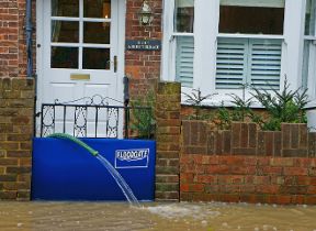
While showers are likely quite widely across the UK on Friday, the east of Scotland and Northern Ireland look likely to see more frequent and impactful rain initially, which has resulted in the issuing of rain warnings. For the east of Scotland, around 20-40mm of rain could accumulate within the warning area quite widely, with 50-100mm possible over higher ground.
For eastern and northern parts of Northern Ireland, the warning highlights some potentially impactful downpours, with 10mm falling within an hour in some spots, with 30-40mm possibly falling over a six hour period. Both of these initial warnings expire on Saturday evening.
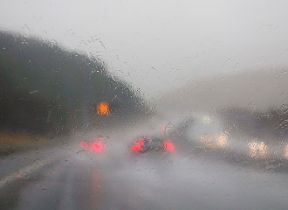
From the early hours of Saturday morning, heavy showers with a risk of thunder, will become more numerous over southern and some eastern areas of England. A yellow warning has been issued, with a chance of travel disruption and flooding for some. This warning remains in force until the end of the day on Sunday, with 15-30mm of rain possible quite widely, with English Channel coasts possibly seeing 50-70mm. Gusty winds will be an additional hazard on immediate coastlines.
Met Office Chief Meteorologist Andy Page said: “The wet and often windy theme is continuing through the weekend for many, with plenty of showers and some longer spells of rain possible in some areas, which has the potential to cause disruption.
“The influence of low pressure is chiefly responsible for this unsettled period of weather, with various areas of frontal rainfall, some with embedded heavier downpours, generally moving northwards through the weekend.
“For the east of Scotland, where rain is falling on very saturated ground, rain is likely to continue through much of the weekend, with a further yellow warning in force in the area from early on Sunday through to the end of Monday. The area then should develop a drier interlude for a short time at the start of next week.”
Further wet and windy weather to come
The outlook for next week is for the UK’s unsettled weather to continue, though the initial focus of heavier showers is more likely over England and Wales. However, there’s a chance of a deep area of low pressure bringing some further wet and windy weather from the middle of next week.
Met Office Deputy Chief Meteorologist Tony Wardle said: “While the start of next week will see this unsettled theme to the weather continue, there’s increasing confidence of a deep area of low pressure influencing the UK’s weather from the west, bringing a more concerted period of wet and windy weather.
“However, at this range, we’re still determining the exact positioning, depth and likely impact of this system, but it’s something that’s likely to influence the UK’s weather from the middle of next week.”
You can keep up to date with the latest forecast on our website, by following us on Twitter and Facebook, as well as on our mobile app which is available for iPhone from the App store and for Android from the Google Play store.