SADIS-API
The SADIS API system (introduced in February 2023) provides access to the higher resolution WAFS data sets being introduced with ICAO Annex 3, Amendment 82. It is the successor to the SADIS FTP which will be retired in 2028.
The SADIS API is :
-
SWIM compliant and conforms to the EUROCONTROL SWIM yellow Profile standards
-
published in the EUROCONTROL SWIM Registry https://eur-registry.swim.aero/services
-
Uses the Open Geospatial Consortium (OGC) Environmental DATA Retrieval (EDR) API framework
In order to use the SADIS API users will need to register (even existing SADIS FTP users), and the SADIS API services user terms and conditions will need to be accepted before access is granted. To start the registration process please email the SADIS Manager.
Data available on the SADIS API
The data sets are summarised below. Full details can be found in the SADIS API User guide which details the full set of WAFS gridded data available.
0.25-degree horizontal resolution WAFS gridded data |
1.25-degree horizontal resolution WAFS gridded data |
|---|---|
|
Parameters
WAFC London and WAFC Washington data will be available. |
Parameters
Max wind height, and max wind u/v WAFC London and WAFC Washington data will be available.
|
|
Forecast Timesteps: T+06 to T+24 at 1-hourly intervals T+27 to T+48 at 3-hourly intervals1 T+54 to T+120 at 6-hourly intervals2 Note: 1Icing, Turbulence and Cumulonimbus data will stop at T+48 2WAFC London data past T+66 will only be produced for the 00Z and 12Z model runs Data will be available as global and regional tiles |
Forecast Timesteps: T+06 to T+36 at 3-hourly intervals Data will be available as global tiles only.
|
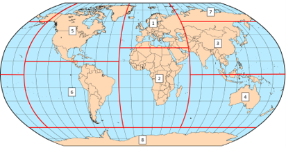
The WAFS gridded data will be available as a global data set or as regional subsets (tiles).
Users are strongly encouraged to use a regional subset if it is appropriate for their activities.

WAFS SIGWX Data - available in test/beta mode, expected to become operational in November 2024 |
OPMET DATA |
|---|---|
|
SIGWX that covers FL100 to FL600 and includes information on the jet stream, turbulence, cumulonimbus clouds, icing, the tropopause, volcanic eruptions, tropical cyclones and nuclear releases.
WAFC London and WAFC Washington data will be available.
|
TAC and IWXXM format.
TAC only format
Graphics
|
|
Forecast Timesteps: T+06 to T+48 at 3-hourly intervals
|
Available data: Data published at 5 minute intervals based on the time it reaches the Met Office. 36 hours worth of data will be held on the system. |
Want to sign-up? Please e-mail the SADIS Manager.
Get in touch
Call us
We are available 24/7.
0370 900 0100Email us
Fill out this short form and we'll get back to you.
Contact Us formFollow us
Linkedin TwitterGet in touch
Call us
We are available 24/7.
0370 900 0100Email us
Fill out this short form and we'll get back to you.
Contact Us form

